|
In addition to the requirement
that source rock exists for the generation of hydrocarbons, and
that reservoir rock exists for the storage and production of the
generated hydrocarbons, traps must also exist to trap, or seal,
the hydrocarbon in place forming a hydrocarbon reservoir.
The fluids of the subsurface
migrate according to density. As previously discussed, the
dominant fluids present or potentially present are hydrocarbon
gas, hydrocarbon liquid, and saltwater. Since the hydrocarbons
are less dense than the saltwater, they will tend to migrate
upward to the surface, displacing the heavier water down
elevation. These fluids will continue to migrate until they
encounter impermeable rock, which will serve as a reservoir
“seal” or “trap.” These impermeable rocks serving as reservoir
seals, of which shale’s are among the most common, are referred
to as confining beds or cap rocks. Traps exist
because of variations in characteristics of rocks of the
subsurface. If impermeable rock does not exist, the hydrocarbons
will migrate to the surface and dissipate into the environment.
In order for a hydrocarbon reservoir to exist, a proper sequence
of events must have occurred in geologic time.
Traps can be classified as:
structural trap:
is a shifting or alteration in
the horizontal formations of the earth's crust. The alteration
is caused by the physical processes of plate tectonics,
continental drift, earthquakes, rifting or the intrusion of
salt, shale or serpentine. The intrusion forms faults and folds
in the original horizontal formations thus creating the traps
necessary for reservoirs Other structures common to hydrocarbon
reservoirs are folds and faults
type of Structural Traps:
1)
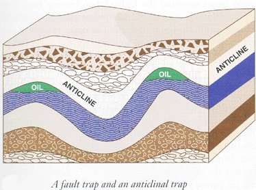
Anticline Traps:
Sedimentary beds are generally
deposited in horizontal parallel planes over a geographic
region, so that many of these sediments will be of essentially
uniform thickness over This trap may exist as a simple fold or
as an anticlinal dome. that region. If geologic activity
should occur, resulting in the folding of these sediments, the
result may be the formation of hydrocarbon reservoirs in
anticlinal traps. Two major potential advantages of the
anticlinal trap reservoir are the simplicity of the
geology and
the potential size of the trap and therefore of the hydrocarbon
accumulation. The high part of the fold is the anticline,
and the low part of the fold is the syncline. Since the
hydrocarbons are the less dense of the subsurface fluids, they
will tend to migrate to the high part of the fold. Consider the
hydrocarbon reservoir illustrated in Figure 18. Hydrocarbon
reservoir rock,where shale is the cap rock formation of this
hydrocarbon reservoir. Sedimentary beds are deposited in a water
environment, as indicated by the presence of limestone’s and
shale’s. During or after lithification, geologic activity causes
folding of the sediments. After folding and lithification, the
sandstone has a 100% connate water saturation. Millions
of years later, hydrocarbon generated in source rock down
elevation from this anticlinal fold is forced from its source
rock into the water-saturated, permeable sandstone. Since
hydrocarbon is less dense than the water, it begins to migrate
up elevation, displacing the heavier water down elevation. As it
migrates upward, pressure decreases. At some point in this
migration, the reservoir fluid pressure might equal the bubble
point pressure of the original hydrocarbon combination. From
this point upward, gas is being released from the hydrocarbon.
Since the gas is so much less dense than the
oil or the water,
it will migrate more rapidly toward the top of the anticlinal
trap. This process of migration and fluid separation according
to density may continue over millions of years in geologic time,
until finally, equilibrium is achieved as the hydrocarbon fluids
accumulate within the trap formed by the impermeable shale cap
rock When this condition of equilibrium is finally achieved,
there will be a gas zone (gas cap) on top of an oil zone and
then a water zone beneath the oil zone.
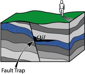
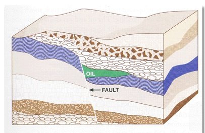
2) Fault Traps :
Fault implies fracturing of rock
and relative motion across the fracture surface. Consider a
possible sequence of geologic events that, in geologic time, .
Sedimentary beds are deposited in a water environment, as
indicated by the presence of shale’s and limestone’s. During or
after lithification,geologic events result in uplift of these
original horizontal sediments, and fracturing and tilting above
sea level, so that the surface rocks are exposed to erosion.
During uplift, the rocks are fractured and slippage occurs along
the fault plane.This brings the shale across the fault so
that it seals the tilted sandstone below the fault. Millions of
years later, hydrocarbon generated in its source rock down
elevation from the fault is forced into the connate
water-saturated sandstone. Since the hydrocarbon is less dense
than the water, it will migrate up elevation, displacing the
heavier water down elevation. This upward migration will
continue until it reaches the fault and is trapped by the
impermeable shale. If the faulting had not occurred, the
hydrocarbon would have continued to migrate upward until it was
dissipated at the surface into the environment. Since faulting
occurred, the shale provides the necessary seal, resulting in
the existence of the hydrocarbon reservoir.Notice that, in this
example, if slippage had occurred to a greater extent, there
would have been flow into the permeable sandstone above the
fault. The hydrocarbon would have been lost to the surface, and
no reservoir would have been formed.This situation
illustrates the significance of geologic probability.
What is the probability that the
relative motion across the fault would have resulted in a
reservoir seal being formed?Geologic events must occur in the
proper sequence, resulting in the proper geologic conditions for
a reservoir to exist. The North Sea hydrocarbon environment is
an excellent example of the
significance of this geologic
probability. Of the hydrocarbon generated in the source rock of
the North Sea, it is estimated that less than 10% was trapped.
Over 90% of the hydrocarbon was lost back to the surface in
geologic time and dissipated into the environment because traps
were not present. Fault traps leading to the presence of
hydrocarbon reservoirs are often difficult to define because of
the complexity of the geology.
3) Salt Dome Traps:
Consider the salt dome geologic
system illustrated in Figure and a possible sequence of geologic
events that could lead to the formation of this salt dome
environment. A major portion of a continental plate was below
sea level at a point in geologic history. Due to geologic
events, this region rose above sea level, trapping inland a salt
water sea. As geologic time passed,the climate changed to a
desert environment. This event could have resulted from movement
of the continental plate near tothe equator. In this arid desert
environment, water evaporated from the salt water sea, leaving
the salt residue on the dry seabed. As millions of years passed
in the desert environment,sand blew over the salt to cover and
protect the salt sediment.Later geologic events resulted in the
sinking of the region below sea level, followed by tens of
millions of years of sedimentation in the resulting water
environment. As time passed, lithification occurred. The desert
sand became sandstone, and the salt became rock salt
(sedimentary salt).
After lithification, this salt
bed was impermeable. It also had two properties significantly
different from typical shale, sandstone or limestone:
• It was less dense, with a
measurably smaller specific weight.
• At subsurface overburden
pressures and subsurface
temperatures, the rock salt was a
plastic solid (it was highly deformable).
The combination of this lesser
density and plasticity resulted in a buoyant effect if flow
possibilities existed. Geologic events caused fracturing of
overlying confining rocks. The salt, forced upward by the
overburden pressures, began to flow plastically back to the
surface, intruding into the overlying rock structures
to lift, deform, and fracture
them. The intruding salt was solid,yet geologically deformable.
It might intrude at an average rate of only 1 inch per 100
years, yet on a geologic time basis, such deformation is highly
significant. This rate would result in 10inches in 1,000 years,
or 10,000 inches (833 ft) in 1 million years. In a geologic time
period of only 10 million years, this salt dome could intrude to
a height of over 1.5 mileoverlying structures. Obviously, a
vertical subsurface structure1.5 miles high is geologically
significant. Since the salt isimpermeable, the region around the
perimeter of the salt domeis an ideal geologic environment for
hydrocarbon traps. The tendency of the intruding salt to uplift
the rocks as it intrudesenhances the separation of the less
dense oil from the more dense salt water by reducing the area of
the oil-water contact.The fracturing of surrounding rocks due to
the intruding salt and the lifting of the rocks above the salt
dome also provide an environment for the existence of fault
traps and anticlinal traps in addition to the salt dome traps
around the perimeter of the
dome. A salt dome region,
therefore, is an excellent geologic environment for all three
types of traps discussed so far.An excellent example of a salt
dome trap is Spindle top near Beaumont, Texas. The first major
discovery and resultant initial oil boom at Spindle top occurred
in 1901. Through the 1890s Patillo Higgins had promoted drilling
for oil outside Beaumont. He concluded that it was an excellent
geologic environment for hydrocarbon reservoirs, because he
noted a location near Beaumont where the surface elevation was
15 ft higher than the surrounding land. This rise was a circle
approximately 1 mile in
diameter. He concluded
that this indicated high points in the underlying geology. In
1901, Captain Anthony Lucas drilled a wildcat well at this
location, resulting in the Spindle top discovery. Future
drilling confirmed that this reservoir existed as an anticlinal
dome trap, with the dome created by the uplift of overlying
rocks by an intruding salt dome in the subsurface, creating the
surface indication of what the subsurface geology might be.The
second oil boom at Spindle top began in the mid-1920s.
When further wells were drilled,
it was discovered that fault trap and salt dome trap reservoirs
existed around the circumference of the salt dome. The drilling
pattern for the wells drilled during this later activity was
almost a perfect circle as these circumferential reservoirs were
developed.
stratigraphic
trap:
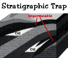
The stratigraphic trap is a
change in the lithology of the rock sequence. This change is
caused by erosional forces or changes in rock type within a
limited areal extent. An unconformity is an erosional feature
where a portion of the geological sequence is eroded and an
impermeable rock is deposited on top of a porous formation. The
process of erosion will enhance or create the porosity and
permeability necessary for the existence of a petroleum
reservoir. Other stratigraphic trapping include channel sand
deposits surrounded by shale, growth of limestone reefs and the
formation of barrier islands or sand bars along the ancient
shoreline.
Classification of stratigraphic trap:
-Primary Stratigraphic Traps:
These traps result from
deposition of elastic or chemical materials. Shoestring sands,
lenses, sand patches, bars, channel fillings, facies changes,
strand-line (shoreline) deposits, coquinas, and weathered or
reworked igneous materials are classified as elastic sedimentary
deposits and can result in stratigraphic traps. An ancient
sand-filled stream channel meander has cut into older
south-dipping shales and created a perfect stratigraphic trap.
The shale plug served as the seal
for reservoirs within a west-plunging structural nose.
Hydrocarbons are trapped in the truncated up dip portions of the
reservoirs. Organic reefs or biohenns and biostromes are the
primary chemical stratigmphic traps; they are built by organisms
and are foreign bodies to the surrounding deposits .The Strawn
and Cisco-Canyon series are limestone reefs that have had
younger
the seal. Differential compaction
of the thicker shales on the Type of stratigraphic trap : flanks
of the reef as compared with the thinner shale at the crest has
created structural closure in younger overlying formations.
Hydrocarbon accumulations have occurred in the Cisco and Fuller
formations as a result of this differential compaction.
Additional traps in other reservoirs arc the result of up dip
permeability and porosity barriers and are either primary or
secondary stratigraphic traps.
Secondary Stratigraphic Traps:
Traps of this type were formed
after the deposition of the reservoir rock by erosion and/or
alteration of a portion of the reservoir rock through solution
or chemical replacement. Secondary tratigmphic traps actually
should fall into the combination-trap classification because
most are associated with or are the result of structural relief
during some stage of development of porosity and permeability or
limitation of the reservoir rock. However, many of the so-called
typical “stratigraphic traps” fall into this category, and it is
felt that it would be impossible tochange the historical usage
of this term. Therefore, secondary stratigraphic traps are
defined for this discussion as those traps created after
deposition and having limitations caused by lithology changes.
Erosion creates a major part of
these through truncation of the reservoir rock. On-lap
deposition (when the water is encroaching landward), off-lap
deposition (when the water is regressing), and the chemical
alteration of limestone result in many secondary stratigraphic
traps) It is a truncation of the Woodbine formation as it
approaches the regional Sabine uplift. A certain amount of
leaching of the cementing material by waters over the
unconformity has resulted in increased porosity and permeability
in the field as compared with similar Woodbine sands in the
deeper portions of the East Texas basin. |
.jpg)
.jpg)
.jpg)
.jpg)
.jpg)