|
Examples of
Stratigraphic
Traps:
1)pinchout:
|
 |
are the
result of the changes in deposition of the sediment.
Thick layers of mud are covered by thinner layers of
sand from migrating shoreline, or by the sand deposited
by large rivers. As sea level changes, or rivers
migrate, the different sand and mud layers are
interwoven creating lenses or pinch-outs. These sand
layers allow the petroleum to accumulate and the mud
rock layers trap the petroleum. can create traps by
burying truncated sandstone or limestone layers with
layers of mudstone. |
2)
Carbonate Reef:
|
 |
are great
places to trap oil. The open cavities between the corals
create excellent reservoirs, and when the reef is buried
by mud, the oil becomes trapped. Many of the large oil
and gas fields in west Texas are found in buried age
reef. |
3)Sandstone Lens:
|
 |
Lenses -
Layers of sand often form lens like bodies that pinch
out. If the rocks surrounding these lenses of sand are
impermeable and deformation has produced inclined
strata, oil and natural gas can migrate into the sand
bodies and will be trapped by the impermeable rocks.
This kind of trap is also difficult to locate from
the surface, and requires subsurface exploration
techniques. |
4) Faces Change:
|
 |
Consider the deposition
near a shoreline of a continent, as distance from the
shoreline increases. From the shoreline out into the
body of water, the particle size decreases from gravel
to pebbles, to sand, to silt, to mud. When lithification
occurs, the silt-to-mud size particles, form shale.
Therefore, in the same sedimentary bed, as distance from
the original shoreline increases, the rock grades from
sandstone, through a transition zone, to shale. Assume
that, after lithification, with further sediments having
been deposited on this original sediment, a geologic
event results in uplift and tilting of this sediment, so
that the shale is “up dip” from the sandstone, as
illustrated in Figure 24. The dip of a bed is the angle
its plain makes with the horizontal.
Later in geologic time,
hydrocarbon generated in its source rock at lower
elevations is forced into the connate water-saturated
sandstone and begins to migrate up elevation, displacing
the heavier water down elevation. This hydrocarbon will
continue to migrate until it encounters the impermeable
shale at the transition zone within the rock. It is
trapped as a result of the change of permeability within
the sedimentary bed, as the transition occurs from
sandstone to shale or from permeability to no
permeability. This transition of properties within the
rock sediment is called a facies change. |
Through the transition zone, the
transition occurs from sandstone to shaley sandstone, to sandy
shale, to shale. As to the distinction between”shaley sand”
and”sandy shale,” as long as the rock has sufficient porosity
and permeability to be considered an acceptable reservoir rock,
it is classified as sandstone. However, when either property has
reduced sufficiently within the transition zone so that the rock
can no
longer be considered an
acceptable reservoir rock, it is considered shale.
Combination Traps:
Combination traps are structural
closures or deformations in which the reservoir rock covers only
part of the structure. Both structural and stratigraphic changes
are essential to the creation of this type of trap. Traps of
this nature are dependent on stratigraphic changes to limit
permeability and structure to create closure and complete the
trap. Up dip shale-outs, strand-lines, and facies changes on
anticlines, domes, or other structural features causing dip of
the reservoir rock create many combination traps.
Unconformities, overlap of porous rocks, and truncation are
equally important in forming combination
traps. Faulting is also a
controlling factor in many of these traps. Asphalt seals and
other secondary plugging agents may assist in creating traps.
Examples
of
Combination traps:
1)Traps Associated with salt domes:
|
 |
A salt dome is a mass of
NaCl (Sodium Chloride) generally of a cylindrical shape
and with a diameter of about 2 km near the surface,
though the size and shape of the dome can vary. This
mass of salt has between pushed upward from below
through the surrounding rock and sediments into its
present position. The source of the salt lies as a
deeply buried layer that was formed in the geologic
past. Salt is an evaporate. Salt beds were formed by the
natural evaporation of sea water from an enclosed basin;
in Louisiana, this occurred in Permian or Jurassic time.
Subsequently, the precipitated salt layer is buried by
successive layers of sediments over geologic time until
segments of it begin to flow upward |
|
toward the surface of
the earth .The origin of salt domes is best explained by
the plastic-flow theory. Salt has a density of 2.2 under
standard conditions. But at a depth of about 12,000
feet, the mass of the overlying sediments exerts a
compressive, downward force, density decreases and salt
begins to flow like a plastic substance. A small
fracture in the overlying, higher density sediments or a
slightly elevated mass of salt above its surroundings
would trigger the upward movement. Once this upward salt
movement begins, salt from elsewhere in the salt bed
moves into the region surrounding the salt plug to
replace the salt that is flowing upward to form the salt
plug. The upward movement of the salt plug, or dome,
continues as long as there is sufficient source of salt
"feeding" the dome OR until the upward movement is
halted by a more rigid formation. Once equilibrium is
reached, upward movement of the salt dome ceases, but
may begin again if sufficient sediments are added to the
weight of the overburden which again increases the load
pressure on the parent salt mass. In Louisiana, the age
of the salt domes is dependent upon which side of the
Cretaceous reef structure you are on. The domes are
oldest on the north side and youngest on the south side.
This also corresponds to the age of the hydrocarbon
deposits discussed earlier. |
2) Unconformity
Consider the sequence of geologic
events summarized in Figure 23. Sedimentation occurs over
millions of years in a water environment, resulting in
horizontal, parallel, sedimentary beds.
Lithification occurs,
followed by uplift and tilting above sea level. As a result of
being uplifted above sea level, erosion occurs over millions of
years, removing rocks down to an erosionalsurface, or
unconformity. Following erosion, the region subsides again below
sea level and is followed by millions of years of sedimentation
in a water environment. After lithification, the first sediment
on top of the unconformity is impermeable shale. The
unconformity represents a discontinuity in the geologic system,
because there is a geologic time discontinuity between the rocks
above the unconformity and those below it. Millions of years
after this sequence of events, hydrocarbon that is generated in
source rock at lower elevations is forced into the connate
water-saturated sandstone. Due to its lesser density, it
migrates upward through the permeable sandstone, displacing the
heavier water down elevation. When the hydrocarbon reaches the
unconformity, it is trapped. This trap is a stratigraphic trap,
and this particular type of stratigraphic trap is referred to as
an unconformity, or “truncation.” The specific type of
unconformity illustrated here is an angular unconformity.
Notice that the hydrocarbon trap
would not have existed had thefirst sedimentary bed above the
unconformity not been impermeable after lithification. Again,
the proper sequence of geologic events was necessary in order
for the trap to exist.
3)Other Traps:
|
 |
Many
other traps occur. In a combination trap, for example,
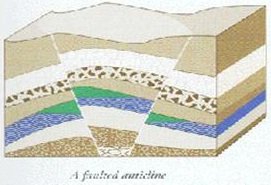
more than one kind of trap forms a reservoir. A faulted
anticline is an example. Several faults cut across the
anticline. In some places, the faults trap oil and gas
(fig- ). Another trap is a pier cement dome. In this
case, a molten substance-salt is a common one-pierced
surrounding rock beds. While molten, the moving salt
deformed the horizontal beds. Later, the salt cooled and
solidified and some of the deformed beds trapped oil and
gas (fig-). Spindle top was formed by a pier cement
dome. |
Lenticular Traps:
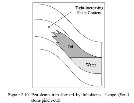
Oil and gas may accumulate in
traps formed by the bodies of porous lithofacies (rock types)
embedded in impermeable lithofacies, or by the pinch-outs of
porous lithofacies within impermeable ones, as seen in Fig.
2.10.
Examples of such lenticular traps
include: fluvial sandstone bodies embedded in flood basin mud
rocks, deltaic or mouth-bar sandstone wedges pinching out within
offshore mud rocks, and turbid tic sandstone lobes embedded in
deep marine mud rocks. Similar traps occur in various
limestones, where their porous
lithofacies (e.g. oolithic limestone or other calcarenites)
areembedded in impermeable massive lithofacies; or where porous
bioclastic reefal limestones pinch out in marls or in mud rocks.
The approximate percentages of
the world’s petroleum reservoirs associated with those major
trap types are given in Fig. 2.11.
On of the present-day Earth’s
surface, over half of the continental areas and adjacent marine
shelves have sediment covers either absent or too thin to make
prospects for petroleum accumulation. Even in an area where the
buried organic matter can mature, not all of it results in
petroleum accumulations. The following statistical data may
serve as a fairly realistic illustration [49]:
• Only 1% by vol. of a source
rock is organic matter,
• < 30% by vol. of organic matter
matured to petroleum,
• > 70% by vol. of organic matter
remains as residue and
• 99% by vol. of petroleum is
dispersed or lost at the ground surface in the process of
migration, and only 1% by vol. is
trapped.
These data lead to the following
estimate: only 0.003 vol.% of the world’s source rocks actually
turn into petroleum that can be trapped and thus generate our
petroleum resources
What
is the difference between each of the three trap types in terms
of how they were formed?
Answer: A Structural trap is formed by tectonic processes
AFTER deposition of the reservoir beds involved while a
Stratigraphic trap is created during deposition of the reservoir
beds. A Combination trap is formed by a combination of processes
present in the sediments DURING the time of deposition of the
reservoir beds AND by tectonic activity that occurred in the
reservoir beds after their deposition.
|